|
  Find us on
Facebook and Twitter Find us on
Facebook and Twitter
|
|
Welcome to the CDXZipStream March 2016 Newsletter
This month we highlight how the CDXZipCode data feed
of CDXZipStream can be used for geocoding, mapping, demographics analysis,
and address accuracy checks. We also review the various mapping
options available with Bing Maps and Microsoft MapPoint, and the
latest update of feeds that use the American Community Survey.
Also: Some newsletter changes ...
You may have noticed that we have renamed this the
"CDX Technologies" newsletter, in order to encompass our
software offerings beyond CDXZipStream. In keeping with our
soon-to-be mobile-friendly website, this month we are testing the
newsletter in both desktop and mobile-responsive formats.
Please contact us if you have any concerns or problems with viewing
these.
|
|
Updated
CDXZipStream ACS Databases
All CDXZipStream feeds that use the American Community
Survey for demographics data have been updated. These are:
CDXACSCBSA: Core Based Statistical Area
demographics for the aggregated 2010-2014 ACS
CDXACSPlace: Place (city, borough, town, etc.)
demographics for the aggregated 2010-2014 ACS. Covers places
with populations of 20,000 and greater.
CDXACSCounty: County demographics for the
aggregated 2010-2014 ACS
CDXACSState: State demographics for the 2014 ACS
CDXACSZCTA: ZCTA (ZIP Code) demographics for the
aggregated 2010-2014 ACS
CDXACSTract: Census tract demographics for the
aggregated 2010-2014 ACS
All the feeds now use 5-year aggregated data, with the
exception of the CDXACSState feed which uses 1-year data. The
Census Bureau has discontinued 3-year aggregated data which we have
used previously.
The ACS is a survey that has been performed by the U.S.
Census Bureau every year since 2005; it has replaced the old
"long form" that used to be part of the decennial (10-year)
census. Starting in 2010, the decennial census now only
consists of the "short form" that covers basic questions
about age, gender, race, and household size. These areas are
covered by the ACS, as well as the more interesting demographic
topics such as educational attainment, individual earnings, household
income, marital status, school enrollment, mortgage status, and
housing value.
With the latest version of CDXZipStream, you can
update your ACS data feeds by selecting "Account" on the
CDXZipStream commandbar in Excel. Then click on the "Check
for Available Database Updates". If you need to purchase a
premium maintenance subscription to obtain the update, you can do
this from your account area on CDXTech.com. The census tract
database is a separate purchase and is not part of the premium
maintenance subscription.
|
Mapping Options in CDXZipStream
 Between
Bing Maps and Microsoft MapPoint, there are more ways than ever for
creating maps in your worksheet using CDXZipStream. Here is a
summary of the options: Between
Bing Maps and Microsoft MapPoint, there are more ways than ever for
creating maps in your worksheet using CDXZipStream. Here is a
summary of the options:
Location Maps - For location
maps use the CDXLocateBing or CDXLocateMP functions, and select
"Insert Location Map" as the returned data. When
using Bing, up to 18 locations can be mapped together, while with
MapPoint locations can currently be mapped one at a time.
Route Maps - Route maps between
one or more locations are available through the CDXRouteBing or
CDXRouteMP functions, by selecting "Insert Route Map" as
the returned data. These maps are also included as part of the
Trip Summary output if you choose to select this option; use
"Route Settings" (for MapPoint) or "Bing Maps Settings"
(for Bing) to specify whether maps are to be included in the Trip
Summary output.
Radius Maps - A radius map
around the center of a ZIP Code area can be created using the
CDXRadius function, working in conjunction with Microsoft MapPoint.
Input the ZIP Code of interest and the radius distance, then
select the "Insert Radius Map" as the result output.
The centroid of the ZIP Code will be indicated with a pushpin,
surrounded by a radius circle of the specified size.
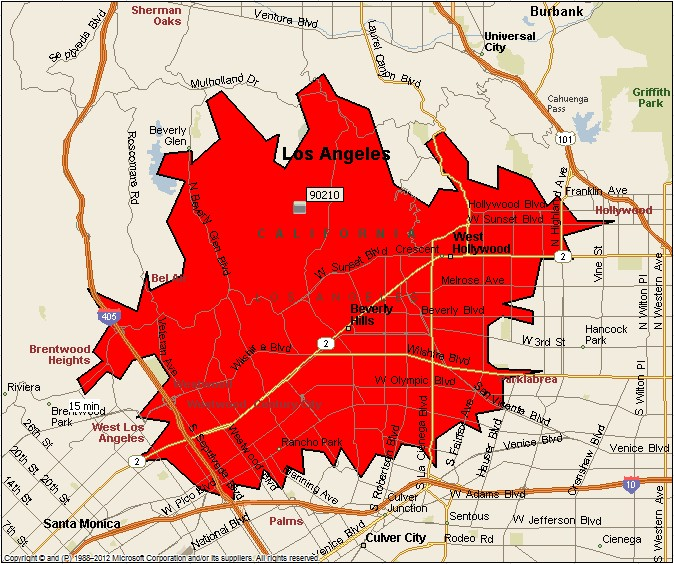
Drive Time Maps - You can also use
the CDXRadius function, working with MapPoint, to create a drive time
map. In this case specify the drive time (in minutes) around
the ZIP Code of interest, and a polygon indicating the driving time
"radius" will be outlined in red, as shown in the
accompanying image.
The maps from Bing and MapPoint are
"snapshot" files and cannot be directly edited. They are
only available in Bing- or MapPoint compatible versions of
CDXZipStream and require entering a Bing Maps license key into
CDXZipStream, or separate installation of MapPoint.
|
|
Features of the Premium CDXZipCode Data Feed
The premium data feed CDXZIPCode is available in all
demographics versions of CDXZipStream, and has a versatile data set
that can be used to closely approximate other CDXZipStream features:
1. Geocoding -
CDXZipCode provides latitude and longitude data for every valid
U.S. ZIP Code, based on the centroid location of the ZIP Code
area. So instead of geocoding a list of specific addresses, you
can just apply this data feed to the ZIP Code of each address to get
approximate latitude and longitude data. The advantages are
that no separate source of mapping data (such as Bing Maps or MapPoint)
is required, the data are returned very quickly, and there will be no
errors in interpreting specific address locations. If your
analysis doesn't require a high level of accuracy, consider using
CDXZipCode as a geocoder.
2. Demographics
- CDXZipCode covers some of the more important data from the 2010
Census and latest 5-year aggregate of the American Community
Survey. So if the more expensive demographic feeds of
CDXZipStream are not in your budget, the data from this feed may
suffice. Demographic topics covered include: median age (by
gender), population (by gender), race, household size, income by household,
and average house value.
3. Address
accuracy check - CDXZipCode includes city and state information
associated with each ZIP Code, so as a simple method for checking
address accuracy, use this feed to get city and state for ZIP Codes in
an address list, and compare the results to the original data.
This approach can catch many errors, and again, doesn't require a
separate source of mapping data such as Bing Maps.
4. Mapping
- As an alternative to creating location maps in your worksheet
using Bing or MapPoint, you can create links to ZIP Code locations in
Google Maps or MapQuest using CDXZipCode. Just select the
fields "Map - Google" or "Map - MapQuest" to create
clickable links for all the ZIP Codes in your list.
If you would like to upgrade to a version that includes
the premium CDXZipCode feed (usually either the Population or
Demographics version) please log in to CDXTech.com and select
"Upgrade License" from the account area.
|
Latest Data
Updates
Canadian and
U.S. data feeds of CDXZipStream were updated as of March 25.
There were 104 changes made to the U.S. database this month.
If you would like to update your database to reflect these
changes, select the "Account" option on the CDXZipStream
commandbar and click on "Check for Available Database
Updates". You can then update each database as
required.
CDXZipStream
updates are a part of the one-year software maintenance
subscription included with your purchase. If you would like to
extend your subscription, please sign in to the CDX Technologies
website and from the account area, select "Buy Data Update".
As always
we hope you find the information here helpful for you and your
organization. You can contact us with your feedback and
suggestions by replying to this email.
The Team at CDX
Technologies
|
|
|
|
|
In
This Issue
Updated
CDXZipStream ACS Databases
Mapping
Options in CDXZipStream
Features
of the Premium CDXZipCode Data Feed
Data
Updates
|
|