Geographic Access Analysis Report
Geographic access analysis is a method used to assess the proximity of various resources, services, or facilities in relation to specific geographic locations. It is an essential report needed by business, the medical industry, government, and other fields. One common use is to understand which stores or offices are closest to a list of customers.
This application allows you to upload a set of location postal codes along with a list of target postal codes in an excel or csv file. Two formats of input are allowed. The first format is two columns of postal codes with the first column being locations and the second column being targets. An example of this file can be downloaded here. Labels can also be associated with the locations and targets as shown in this example file.
The user can set a radius distance along with the maximum number of targets to be returned before starting. Only targets within the radius specified up to the maximum number will be shown. Both US Zip Codes and Canadian Postal Codes are supported. The tool can analyze up to 300 locations and 2,000 targets.
After the input file is uploaded a preview of the output report will be shown. This shows the closest locations by distance in ascending order for the first few targets in the file. A count will be shown with each target showing the number of locations within the radius.
Once the preview screen is approved an option to purchase the complete report will be presented. The cost of the report is $0.02 or 2 CDXStreamer requests per target with a minimum charge of $9.95. An example output report can be reviewed here.
For larger reports or specific addresses please check out our CDXZipStream product with the Geographic Analysis template for Excel.
You can also contact us at customsolutions@cdxtech.com to run special case reports for you.
Welcome!
Click the button to get started generating your report!

Upload your postal code file containing Locations and Targets in csv or Excel .xlsx format in a single worksheet.
For more detail on this, please click on the File Formatting Help tab above.
Your data can be either US or Canadian Postal Codes. The maximum file size is 300 locations by 2,000 targets.
The cost of the report is $0.02 or 2 requests per target with a minimum charge of $9.95.
Upload your Postal Codes
Drop your Text, CSV or Excel file here
We support both Excel and CSV file formats as inputs.
You can upload files which contain your location data and targets in two and four column formats.
| Two Column Example: |
|
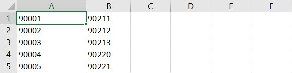
In this format your locations are in the first Column A and your targets in the second Column B.
Here is an example showing how your data file should look for two column formatting: |
|
| Four Column Example: |
|
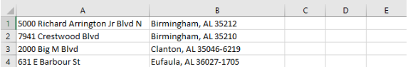
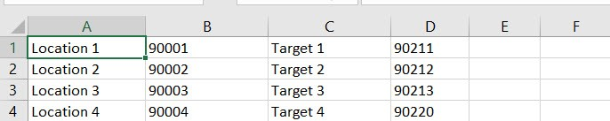
In this format labels for locations are in column A followed by the location postal code. Similarly, column C is used for the target labels and column D the target postal code. Here is an example showing how your data file should look for four column formatting: |
 |
Geographic Access Analysis ReportPreview
Buy this report with CDXStreamer!
Use your CDXStreamer account to download this file for lower costs and no minimum charge.
All of our online tools can be used with your CDXStreamer account!
LEARN MOREThe use of this tool is subject to the following End User License Agreement.